
Home at last. We started from our daughter's house in Jamestown about 2 months ago, and our finishing up our trip at her house on September 11th. We have driven 11,500 miles. That is about the same amount of miles as it would be to travel clear across the United States and back twice. We believe we have traveled 90% of the roads in British Columbia, the Yukon Territory, and Alaska that you can reach by road.
The dogs and our girls are glad to have us back. We are thankful to God that he kept us save from harm, with no troubles at all. We are truly grateful for this wonderful experience He has blessed us with.
And thanks to all that helped make it all possible by caring for our responsibilities while we were gone.
Saturday, September 11, 2010
Friday, September 10, 2010
Boardman, OR to Redding, CA
We saw a number of tugs and barges while we were camped at Boardman on the Columbia River. We drove along the Columbia River and then we headed South on Hwy 97 towards Weed and Mount Shasta. We spent the night on the Sacramento River in Redding. This makes 4 nights in a row that we have camped alongside a river.
Thursday, September 9, 2010
Radium Hot Springs, BC to Boardman, OR on the Columbia River
There were lots of beautiful mountain scenes today but we just relaxed and enjoyed them and didn’t photograph them. We stopped for the night on the Columbia River. We had a view of the river from our dining table.
We took an after dinner walk along the river and photographed an old tug boat. Later, we watched the sunset.
For the first time in two months, we didn’t have to run our heater last night and we were able to put on short sleves in the morning. The sun was shining. We plan to be home by Sunday night.
We took an after dinner walk along the river and photographed an old tug boat. Later, we watched the sunset.
For the first time in two months, we didn’t have to run our heater last night and we were able to put on short sleves in the morning. The sun was shining. We plan to be home by Sunday night.
Wednesday, September 8, 2010
Jasper National Park - Athabasca Falls
The falls are so beautiful, you can't really capture them with photos, so here is a video of the falls. Hope you enjoy them.
Click on picture to play video. Sorry for the poor quality.
Click on picture to play video. Sorry for the poor quality.
 |
| From Sep 8 |
McBride, BC to Radium Hot Springs, BC
We drove through Jasper and Banff National Parks today. The mountains were in the clouds most of the day and we had small amounts of rain off and on during the day. The highlights of the day were the mountains, the waterfalls, the ice fields, and Lake Louise.
Lake Louise is one of my very favorite places. Besides being beautiful, I have been here a number of times in the past. I was here in the late 50’s with my parents, with Grant and my parents in the 70’s when Janine was a baby, and in the late 80’s with Janine and Kristy. Grant and I had a late afternoon tea at the Chateau Fairmont Lake Louise with a view of the lake and the glacier across the lake. What pleasant memories I have of that place. Having tea there with the lovely view was very special to me.
We spent the night in Radium Hot Springs. We pulled in after dark and the camp was essentially full; we had to camp in a dry tent site. It was quite difficult making our way into the site in the dark.
Tuesday, September 7, 2010
Kitwanga, BC to McBride, BC
We decided not to go to Prince Rupert, BC. We had been there before on the Alaska Cruise we took a few years ago, and we decided that the main thing we would have liked to see there is the Railroad Museum. We decided it wasn’t worth a 300 mile round trip to drive out there. So, we headed East on Yellow Head Highway (H 16), which stretches from Prince Rupert on the West Coast of British Columbia and passes through Prince George, BC on to Jasper, Alberta. Jasper is in the Canadian Rockies and is probably our favorite place to see mountains in all of North America. So, we will be driving through the Canadian Rockies on our way home.
We spent a couple of hours at the Railroad Museum in Prince George. It was a very nice museum.
We got our first views of the Canadian Rockies coming into McBride, BC.
We spent a couple of hours at the Railroad Museum in Prince George. It was a very nice museum.
We got our first views of the Canadian Rockies coming into McBride, BC.
Monday, September 6, 2010
Dease Lake, BC to Kitwanga, BC
We are still on the Cassiar Highway (H 37). We left Dease Lake at 6am because there were 30 Airstream Trailers there in a Caravan, and we wanted to get out before the Caravan. At least that’s why we thought we were leaving so early. I think the Lord had plans for us. About 10 miles South of the campground, we were flagged down by a young woman (in her 20’s) and her sister with a 2, 3, and 4 year old in the car. The temperatures were in the 30’s and they had been there all night without gas. We drove to the next town for gas, and waited for the store to open at 8am. The store owner’s boy friend drove the young woman back to her vehicle with 5 gallons of gas. We were the first people to stop to help her. They had had had an interesting experience with an Indian Woman that was an Indian Elder that didn’t help them but said and did some strange things that made them nervous. I think the Indian Woman was watching out for the sisters and the 3 toddlers, even though she did not help them.
We saw a moose and her calf on the way to get gas, but with our priorities on the women and children, we didn’t stop for pictures. We stopped for gas for ourselves in the town of Bell II. It was $105 for 22 gallons!!!! I think that is the worst that we have paid on the trip.
We took the side trip to Stewart, BC and Hyder, AK. The road is called the Glacier Highway (H 37A) because there are so many glaciers on both sides of the road. The views are amazing. Stewart, BC sits at the confluence of the Bear River and the Salmon River at the Portland Canal. We figure there are bear in the Salmon River and salmon in the Bear River. There is a nice estuary in Stewart. You go though customs to get between Stewart, BC and Hyder, AK, but there is no U.S. Customs here, only Canadian Customs. Hyder has a long wooden bear viewing platform on the Salmon River. It is getting near the end of the salmon run season. We were really excited about seeing the bears, but the bears didn’t come out to see us today. From Hyder, there is a 26 mile road to Salmon Glacier which comes right up to the side of the road. You only have to step out your car door to walk on it, but we didn’t go. The 26 miles resembled Italian Bar Road, at it’s worst, a little too much for us today.
We went on to the town of Kitwanga, BC, where we spent the night. We did some research on Prince Rupert in order to decide if we would drive there tomorrow. We decided to skip it. The thing there that most interested Grant was the railroad museum. There was a salmon counting operation going on near our campground that night. The woman at the campground said it was a 20 minute walk. We walked about 15 minutes out and decided it was a little to remote given the number of bears we had seen locally. A truck drove by with two of the men doing the counting. They said that a mama grizzly and her 3 cubs had come up to them while they were counting. They scared her off with a horn. Glad we didn’t come across her on foot. We went back to the campground and got the truck and went out for a look at the salmon counting operation. The counting is being done by Gitanyow Fisheries. They guys doing the counting say their company is on Facebook.
Sunday, September 5, 2010
Whitehorse, YT to Cassiar Hwy (H 37), BC
We drove the Alcan from Whitehorse, YT almost to Watson Lake, YT. We turned south on the Cassiar Highway, just before Watson Lake. The Cassiar Highway is beautiful with lots of mountain and lake and river views and it is a very infrequently traveled road. Grant though we weren’t going to get any pictures today, but the Cassiar Highway proved him wrong.
Be sure to see the picture of the sign entitled “South to Alaska”, “Hyder, AK 669 KM” ( 416 miles). Hyder is the town farthest to the South in Alaska that you can drive to. It is 2 miles from Stewart, BC. It is about 40 miles west of Cassiar Highway. We are going to go there tomorrow…
We saw a bear on the highway. He walked along the highway next to the truck for about 100 ft before turning off into the woods. We stopped at Jade City. 95% of the worlds’s jade comes from the Cassiar Mountains. I had to see some of the intricate jade carvings. We spent the night at Dease Lake, BC. The campground was full, but the owner let us park next to the house, where we had electric and water.
Saturday, September 4, 2010
Dawson City, YT to Whitehorse, YT
We are headed towards home. We still plan to see some places we didn’t see on the way up. Last night we had dinner at Sourdough Joe’s. This morning we got pecan sticky buns at Cheechako’s Bake Shop to eat later as a morning snack. It’s quite appropriate that the two food establishments are next door to one another. In Alaska and the Yukon, Cheechako is a newcomer, greenhorn or tenderfoot, and the opposite of a sourdough or oldtimer. The word originated from Chinook jargon, a trade language that combined English and Indian dialects. The name sourdough comes from sourdough bread, a staple of early homesteaders. Originally, the term meant early settler or prospector who probably used the hardy mixture; but today, a sourdough may be anyone who as lived in Alaska or the Yukon for most of their life. I also heard that since they ate sourdough bread every day that they actually took on a sourdough smell.
It was a beautiful crystal clear day driving from Dawson City to Whitehorse. There is so much Fall color and the mountains were beautiful. Since this makes three times over this drive for us we just relaxed and enjoyed the scenery and didn’t take pictures of the drive. We have put 8230 miles on the truck so far!!!
It was a beautiful crystal clear day driving from Dawson City to Whitehorse. There is so much Fall color and the mountains were beautiful. Since this makes three times over this drive for us we just relaxed and enjoyed the scenery and didn’t take pictures of the drive. We have put 8230 miles on the truck so far!!!
Friday, September 3, 2010
Chicken, YT to Dawson City, YT - Top of the World Highway
We were up bright and early and in line for the 8am convoy at about 7:40am. The convoy didn’t leave Chicken until a little before 9am. The starting point for the convoy was at “Lost Chicken Creek”. We hoped that wasn’t too descriptive of our upcoming journey. While we waited, we visited with the flag woman. She told us that the night before a big rig had come in with a large piece of excavating equipment, and he couldn’t negotiate a turn in the road. He got into a precarious position where he nearly lost both the rig and excavator over the side. They had to bring in other equipment to stablizie the rig and offload the excavator before they could move the rig. We were glad to have the pilot car as it let us drive down the middle of the road. The edges of the road were still muddy in places from the repairs. And, we knew that the pilot car new the road and would keep us safe. The pilot car and convoy of about a dozen vehicles traveled about 20 miles together. Many of us ran into each other again at the Canadian Border Crossing and at the ferry that crosses from Top of the World Highway into Dawson City.
As we were leaving Chicken, it was VERY foggy. We hoped that we were going to be able to see the views from Top of the World Highway. No worries, the fog cleared.
The Taylor Highway goes to Eagle. We didn’t go all the way to Eagle, we turned onto Top of the World Highway at the junction and headed for the Canadian Border and Dawson City. There is a nice free ferry from the Top of the World Highway into Dawson City, with good views of the Yukon River. The ferry had broken down and they were making repairs on the Dawson City side. We waited nearly 2 hours to cross on the ferry. We arrived in Dawson City about 4:30 pm. It was a long but rewarding day.
We had dinner at Sourdough Jack’s and we went to Diamond Tooth Gerdies, where Grant did the can can with a can can girl. See the pictures; I have proof!!!
Thursday, September 2, 2010
Fairbanks, AK to Chicken, YT
Grant got up early and caught the sunrise in Fairbanks this morning. But, the real treat for the day was that we got a view of Mt. McKinley as we were driving out of Fairbanks. Now we belong to the 30% Club!!!
In Delta Junction, we went to the Sullivan House Roadhouse and Historical Museum. Grant took a lot of pictures of antique equipment. He likes antique vehicles… He was particularly impressed with the 6x6 vehicles that had 3 axles, with the back two axles each having 4 wheels. There are roadhouses all over Alaska. Travelers used them for lodging. Roadhouses were spaced apart so that it wasn’t more than a day’s journey from one Roadhouse to the next. Delta Junction is the northern terminus of the Alcan Highway. It’s southern terminus is at Dawson Creek
From Delta Junction we will travel the Alcan Highway to Tok. From Tok, we are going to head north to Chicken and then try again to cross the Top of the World Highway into Dawson City. We tried to take the Top of the World Highway from Dawson City to Tok on our way to Alaska, but the road was closed due to a massive slide that took out a major portion of the highway.
When we got to Tok, we checked the road conditions and found that they road was open. The vehicles would be driving out of Chicken by caravan with a pilot vehicle. There were two scheduled caravans a day, one at 8am, and one at 2pm. We decided we wanted to be on the 8am crossing and that it would probably be wise to drive to Chicken tonight so that we would be sure to not miss the 8am crossing. The visitor’s center in Tok had some pictures of a couple of washed out areas of the highway. I have included two of them. The first is on Taylor Highway milepost 81. A culvert washed out leaving a hole approximately 20 feet deep and 60 feet wide. The hole extends downhill to the Walker Fork River approximately 150 feet away. The second is on Taylor Highway milepost 115. The "Big" slide is 750 feet long, and the road is totally buried 20 feet thick in debris. This happened because of all the rain in July, while we were in Dawson City, which prevented us from crossing at that time. A man lost his life going off the road, at that time.
The campground we stayed at in Chicken had wifi, but it only had electricity from 7am to 9pm. It had no water or sewer. It was situated right next to a gold dredge. I thought I had the blog done for the day and could post it before bed time, but Grant had a fine time taking pictures of the town of Chicken and the gold dredge…
Wednesday, September 1, 2010
Dalton Highway to the Arctic Circle
There were stars visible in the sky at 5am, so we decided to give it a try. We could always turn back. We didn’t turn back. We made it to the Arctic Circle!
We didn’t know what to expect. With all the permafrost and tundra, we thought it might be a wasteland. We were wrong; it was beautiful and gave us spectacular view of mountains and Fall color.
It was 170 mile drive, mostly on gravel - one way. It took 12 hours. Temperatures were quite reasonable during our drive, probably in the 50’s, but before the sun rose, the temperature was 27.
The Alaska pipeline crosses back and forth and parallels the Dalton Highway all the way to the Prudhoe Bay on the Arctic Ocean. So, we got lots of views of the pipeline snaking its way back and forth and up the hills.
We found the tundra to be quite beautiful. Low growing shrubs that grow in small amounts of dirt above the permafrost. The plants freeze in the winter and grow again when the tundra thaws in the Spring.
There were Tors out near the Arctic Circle. There were also some on the road to Chena Hot Springs. They are created by volcanic action and get heaved to the surface by the permafrost. One Tor is called the finger. It points towards Fairbanks and bush pilots sometimes use it to point the way to Fairbanks.
When we crossed the Yukon River, the fog had settled in low on the river, and we couldn’t see the water, and could barely see the bridge or the road. On the return trip, however, we got some good views of the river.
Tuesday, August 31, 2010
Chena Hot Springs
Janine and Kristy left for home last night. We slept in this morning, edited and uploaded pictures to the blog, and did our laundry. Then we drove to Chena Hot Springs, about 60 miles Northeast of Fairbanks.
Grant took pictures of antique car equipment, while I thoroughly enjoyed the hot springs.
We have been debating for days whether to go to Barrow or Prudhoe Bay to put our toes into the Arctic Ocean. In Barrow, we could also see some Eskimo Indian culture. Or, we could just go to the Arctic Circle. Or, we could not go at all. Arctic Ocean tours to Barrow and Prudhoe Bay are very expensive. A trip to Prudhoe Bay by road is a 3 days and 2 nights trip. Driving on the Dalton Highway to the Arctic Circle is about 12 hours round trip on a gravel road, with lots of big trucks. There are lots of warnings against driving on the road. We definitely did not want to do it in the rain. So, we finally decided to set the alarm for 5 AM. If the sky was clear, we would drive to the Arctic Circle. If it was cloudy or raining, we would skip it. Tomorrow will tell.
Monday, August 30, 2010
Fairbanks, AK - Janine and Kristy Depart
Today is Janine and Kristy’s last day in Alaska. They leave for California tonight. We will miss them. They planned this wonderful trip and we are very grateful. We will miss them.
Our first stop for the day was the Fairbanks Visitor’s Center. Then we went to the Fairanks Ice Museum. Every year they have an ice sculpturing contest. They cut huge chunks of ice out of the river. Some of the exhibits are saved in the Ice Museum. We also got a demonstration of carving an ice sculpture.
We also took a paddle wheel ride on Discovery II on the Chena River. Prior to the boat ride. We met and visited with Lance Mackey. He has won the Iditarod the last four years straight. He is also a cancer survivor. I think we are going to be watching the Iditarod next March. I believe we have met at least five Iditarod dog mushers, and at least four have been winners!!! We also saw Susan Bucher’s kennels today. She won the Iditarod for several years in a row, but she lost the battle with cancer. We met her husband, Dave Monson. Dave put the dogs through a race pulling an OHV with no engine, but beefed up brakes.
In Alaska, a large percentage of people own and fly private planes. Sometimes they have regular tires; sometimes they have balloon tires for landing on ice. Sometimes they have pontoons for landing on water, and sometimes they have skies for landing on snow. We saw a pilot take off and land on the water on the paddle wheel boat ride.
Next we saw some demonstrations at a Chena Indian Village. We saw filleting and drying fish. We heard about using animal skins for clothing and saw a ceremonial coat.
After the paddle boat ride, we went back to our little trailer and cooked some of the halibut that we caught in Homer for dinner and then we took the girls to the airport.
Sunday, August 29, 2010
Nenana, AK to Fairbanks, AK
Our first stop of the day was the Nenana Visitor’s Center on our way to Fairbanks. Riley, at the visitor’s center was an Iditarod winner. The visitor’s center has a sod roof. Actually, quite a few buildings, we have seen, here in Alaska, have sod roofs.
Every year in Nenana they have a contest to see who can come the closest to guessing the exact date and time when the ice flow in the river will break up. They put a tripod on the ice in the river. It is attached by cable to a clock in a tower, when the ice breaks up, it pulls the cable and the clock stops and an alarm sounds and the contest is over. For $2.00, we bet that in 2011, the ice will break up on April 25th at 3:33 AM. When the ice breaks up, it sort of explodes, sending huge chucks of ice up to 35 ft in the air.
With Kristin having worked for Sierra Pacific Industries, we were surprised to see a palate of SPI lumber in the trail freight yard at Nenana.
We drove along the Parks Highway to Fairbanks. After we dropped our trailer at camp for the night, we went to Santa Claus House in North Pole, AK. The reindeer there looked really healthy.
Next we went to Pioneer Park in Fairbanks. The train we saw there was used by Warren Harding when he visited Alaska. The Riverboat was the Nenana Riverboat. It now has quite an extensive and authentic layout of all the villages on the Nenana River. They are set up sort of like a railroad layout along the walls.
Saturday, August 28, 2010
Denali National Park & Grant's Birthday
It’s Grant’s birthday and we are headed into Denali National Park for a 12 hour tour to Kantishna in Denali National Park. Private vehicles can not drive there so you have to take a tour if you want to go that far. It’s a rainy/fooggy day so we won’t see Mt. McKinley. We’re glad we chose to see it by plane yesterday.
One of the things we learned on the way to Kantishna was that we were now members of the 70% club. 70% of the folks that come to Denali National Park never see Mt. McKinley. It is nearly always hidden in cloud cover.
We saw two wolves on the trip. Since there are only 59 wolves in 6 million acres of Denali National Park, I would saw we were blessed. The moose antlers are from two moose that locked horns in battle and then could not separate. So, they died of starvation. Sad, but apparently it is a somewhat common occurrence.
There was lots of Fall color: reds, orange, yellow, gold and green. Janine took dozens of pictures of the hills just to get all the colors. She said she was imagining how they would look in a quilt. Janine and Kristy have always wanted to go to the Smokey Mountains or New Hampshire for Fall color. Who would have guessed they would see it in August in Alaska.
Fannie Quigley lived in Kantishna. She was a character and a survivor. She was famous for her blueberry pies. The secret ingredient was bear fat. She was a miner, gardner, hunter, dog musher, and a fisherman. She escaped an abusive first husband by loading her belongings in a dog sled, and pulling the dog sled herself. Her second husband left for an easier life in Seattle, but Fannie toughed it out here.
I think we have seen bear and/or moose nearly every day since the girls have been here.
Friday, August 27, 2010
Wasilla, AK to Denali National Park
We drove from Wasilla to Denali National Park today. The girls have been wanted to go to the East Coast to Fall Color. Well, it is Fall here in Alaska, and the Fall colors are just beautiful. There are lots of reds, oranges, yellows, golds and green.
When we arrived in Denali, the first thing we wanted to see were the dogs used in dog mushing for maintenance of the park. In the winter, the park closes to vehicles and all back country is maintained by the park rangers using the dogs. We got to pet the dogs and see them in a demonstration race.
Next, we went to see the train that comes through Denali National Park. Then, we drove the paved portion of the road through Denali that they allow the public to drive on to the end of the road. The Fall colors were amazing. On our way back, we stopped to see the Savage River Cabin used for Sled Dog Patrols in Winter. Similar cabins are placed a days journey from each other into the park. And, we saw a mother bear with her cub.
For dinner, we attended the Cabin Nite Dinner Theater. They had a good comedy show feature the early pioneers of park era, and all you can eat ribs and salmon. The salmon was excellent. I got the recipe for the sauce!
Thursday, August 26, 2010
Wasilla, AK and the Iditerod; Talkeetna, AK and flight over Denali
We went to the Iditerod Trail Headquarters in Wasilla, AK. We got to pet the puppies, ride a sled pulled by Iditerod trained dogs, and meet the son of the founder of the annual Iditerod Races. Joe Reddington Sr, was the founder of the races. We met his son, Raymond, who know runs the family kennel now. Both of his sons will be racing in 2011.
From there, we went to Talkeetna. We took a picture from the Princess Lodge of Denali and Mt. McKinley. It was shrowded in clouds. We decided to take a flight over Denali since we knew it was going to be raining the next day when we drove to Denali. Besides the views of Mt. McKinley, we got incredible views of 13 glaciers. There are a few cabins out in the ice fields. These would be summer lodgings for vacationers. You would have to fly in to your lodging.
After the flight, we returned to the village of Talkeetna. One of the things we found interesting there was a John Deere ice cream machine. Apparently the Amish make these, and you can order one from them. We had to treat ourselves to homemade ice cream.
It’s off to Denali National Park tomorrow.
Wednesday, August 25, 2010
Palmer, AK and Hatcher Pass
On the way out of Valdez, we saw a mother bear and 3 cubs! What a thrill. It takes a very healthy female bear to have three cubs. Having seen all the salmon swimming upstream in the Valdez area, it shouldn’t be a major surprise to see her with three cubs.
Palmer was established about 1916 as a railway station. Before that it had been a trading post used by the Athabascan Indians starting in 1890. In 1935, as part of Roosevelt’s New Deal, Palmer was planned and established as an agricultural community in the Mat-su Valley for Alaska. 203 American farm families, struck by the dust bowl and the Great Depression, were hand picked to start farms on 40 acre plots in the area. They were offered one of 5 floor plans. They houses and funding for furnishings and other goods to start a new life were put into a 30 year mortgage for them to pay off. With the long summer days, they grow amazing and huge vegetables, and the flowers that grow nearly everywhere are amazing.
In Palmer, we saw a new concept that we liked. At the Tesoro Alaska Gas Station, they were offering “Gas for Grades”. I think that would be a great idea in the “ lower 48” ( as the Alaskans refer to the rest of us) .
We drove to Hatcher Pass out of Palmer and saw some amazing views of mountains and the Independence Mine. There were some steep grades, but the views were stunning. The locals were in the mountains picking blueberries. We also saw some beaver dams along the way in the water.
Tuesday, August 24, 2010
Valdez - Columbia Ice Glacier Tour
We started the day with a tour of the Valdez Museum. Then we took a boat tour of the Valdez Harbor and the Columbia Glacier and Ice Flow.
We saw eagles, birds, ducks, sea otters, and sea lions. We stopped for awhile to watch the sea lions play. They came right up to the boat and swam and played right along with it for a time. The ice bergs were pieces of ice that broke off the glacier. The Columbia Glacier calves off millions of tons of ice each day. They are beautiful with lots of blue in them. Because they came in so many shapes, we imaged them as different animals and objects, much like you do with clouds. The ice bergs are about 95% below water. Sometimes, their center of balance changes and they flip over. When they flip over, they are very blue-green crystal ice on the top.
Valdez was destroyed in the 1964 Good Friday earthquake. The Army Corp of Engineers condemned the town and relocated it a few miles away. The quake measured 9.2 on the Richter scale. After the boat cruise we drove to Old Valdez to see the old town. There is very little left. The old town area itself is chain link fenced although the gates are now without padlocks and standing open.
Monday, August 23, 2010
Glenallen, AK to Valdez, AK
We will be driving to Valdez today along the Glenn Highway to Glennallen, and then south on the Richardson Highway to Valdez. We have driven more than 6,000 miles on this trip so far. Most camp grounds have wi-fi, but we don’t always have the pictures labeled and ready to go for a blog post. So, we are updating the blog as time permits. The mountains and rivers and lakes are just really amazing along this drive.
We saw the Alaska (Alyeska) Pipeline on the way into Valdez. There are expansion joints in the pipeline that let it expand at least 4 feet left and right as well as forward and back. There are also heating elements in places to keep the oil flowing. They use “pigs” to clean up the natural wax buildup that occurs along the pipeline. They put in overhead pipes where vehicles can drive under the pipeline that prevent trucks that are tall enough to damage the pipeline from hitting the pipeline. Most of the pipeline is buried, but not all.
We stopped at the Solomon Gulch Fish Hatchery and the U.S. Forest Service Spawning Area. We saw bear going for the easy catch near the fish hatchery.
The last picture is from an overlook in Valdez at the Civic Center. You can see the mountains, the ocean, the town and the harbor.
Sunday, August 22, 2010
Portage, AK - Alaskan Conservation Center
We left Soldotna early in the morning in route to Valdez. Everywhere along the rivers, people are out fishing. The red salmon are done. They are spawning and dying. People are fishing for the silver salmon and the trout.
We really enjoyed our time in the Alaska Wildlife Conservation Center. The center is home to orphaned and injured Alaskan wildlife. We saw Wood Bison, Musk Ox, Elk, Moose, Caribou, and Eagles. We learned that reindeer are the same as caribou. Reindeer are tame caribou. There was a baby musk ox called Mukluck. His mother gave her life to protect her baby from a bear. Musk Ox are ice age animals that were nearly extinct. Their under fur makes the softest yarn. Kristin got two balls of yarn along with a book of knitting patterns. The proceeds from the sale of the yarn go to native Eskimo peoples. There were beautiful mountain views from the Glenn Highway, even though it was raining.
We spent the night near Glennallen. We are off to Valdez tomorrow.
Saturday, August 21, 2010
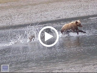
Bear Viewing Video 2
Here's the second video of a bear chasing and catching fish.
Click on the image to view the video. It will bring up the video on another website, hosted by picasa.
Click on the image to view the video. It will bring up the video on another website, hosted by picasa.
Bear Viewing Video 1
We caught two short videos clips on the digital camera of the bears chasing and catching a fish. The resolution isn't great, but the videos are still cute. I'm posting them in two separate posts.
Click on the picture to actually view the video. It will bring the video on another website, hosted by picasa.
Here's the first :
Click on the picture to actually view the video. It will bring the video on another website, hosted by picasa.
Here's the first :
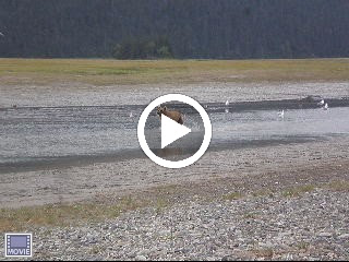
Homer, Alaska & Clark National Park Bear Viewing
We are off to see the bears - up close and personal. The flight to view the bears is with Kbay Air out of Homer. Our trip to Homer, again, provided more excellent views of Cook Inlet, the volcanoes and mountains on the other side, and the Homer Spit area. I think if I were to move to Alaska, I would want to move here. I love the mountains and the water.
Our intended destination was KatMai National Park in the Aleutian Range. However, as we were flying over KatMai, we found it to be socked in with weather, and we couldn’t land. So, we flew on to Clark National Park. It is the newest of the National Parks and is North of Mount Redoubt on the Cook Inlet. We saw lots of beautiful scenery from the air, and were able to view bears fishing from the air. We landed on the beach (no runway). It felt like driving to fast in a dune buggy.
We walked along the beach to an area where the bears fish as the tide is going out. They like to fish in a few inches of water. The water is so shallow that you can often see the top of the fish out of water. The water was filled with Chum – a type of Salmon. We affectionately named the bears we saw. It was such fun to watch them romp through the water like a cat chasing a moving object or a dog chasing after a ball when you throw it. We thought they reminded us of our dog Toby. We were surprised that we could get so close to the bears. One juvenile, that was running away from a bigger bear, after the juvenile’s latest catch ran right towards us and was turned back by the guide when he was about 5 feet away. The bears weren’t interested in us. They were interested in fishing and chasing the fish in the water, trying to catch them. We stayed as a tight knit group. Apparently, the size of our group makes the bears see the group as a single blog bigger than they are and not to be bothered. Be sure to look at the two videos of the bears chasing fish that I am posting. They looked like big teddy bears and never seemed intimidating at all.
We are off toward Valdez tomorrow.
Friday, August 20, 2010
Cooper Landing Rafting Trip and Trip to Seward
It was another sunny beautiful day. We went to Cooper Landing for a rafting trip on the Kenai River. There were rapids, but they were gentle and very enjoyable. We were fully rubber suited from boots to pants to jackets. Cameras were placed in zip lock bags as we approached the sections with rapids. We saw lots of bald eagles and large schools of red salmon that broke the water. There were lots of fishermen trying to catch the trout that are in the bottom of the salmon nests feasting on the salmon eggs. Once the salmon turn red, as they swim upstream to lay their eggs and die, apparently they are no longer good eating. So, for the most part, the fisherman were catching and releasing the salmon and going for the trout.
After lunch, we went to a quilt shop in Cooper Landing. We had to laugh, it’s called “Bearly Threaded” while our quilt store in Sonora is called “Bearly Quilting”. And, we bought a few more fat quarters for our Yukon and Alaska quilt.
After our quilt shop stop, we went towards Seward, with a stop to hike to the Exit glacier. We met up with two of our fellow SOWERS project team members on the hike to the glacier (Lynda and Dave). They allowed Janine and Kristin to sleep two nights in their trailer so Grant didn’t have to sleep out on the ground for two of the nights. Thank you so much Lynda and Dave.
After Exit Glacier we went to Seward to see Resurrection Bay with the girls. The skies were blue and it was so much easier to see the mountains and the bay this time. We saw where the Iditarod Sled Dog Race starts and a sea otter in the bay. Later, on our way back, we were blessed with a beautiful double rain and breath taking sunset.
Thursday, August 19, 2010
Solid Rick Bible Camp - Soldotna, AK (Work Day 12)
Today was the last work day at Solid Rock Bible Camp. It was also the first sunny day we have had since we came to Alaska. The men finished the sheet rock work. The woman finished up some cleaning and reorganized the sweatshirts and tees in the snack shop. Then, Grant and I headed off to the Anchorage Airport to pick up Janine and Kristin. We took a few pictures along with way. We were treated with an incredible sunset. Their flight arrived at 11:20. We arrived back at the camp at 3 AM. Our sleeping arrangements are for Grant to sleep outside on the ground and the three girls to sleep in our little trailer. Poor Grant, but he doesn’t complain.
Wednesday, August 18, 2010
Solid Rick Bible Camp - Soldotna, AK (Work Day 11)
Don and Jenny, from our SOWERS team, left to go back to South Dakota because of a wedding they plan to attend. So, we took group pictures and project pictures before getting together as a group to pray for them for travels mercies and blessings on their way. We took a picture of the entire SOWERS team in front of the Solid Rock for which this Solid Rock Bible Camp is named. It was hard to see them go. This team has really come together and connected on a personal level. We have all come to love each other. After work today, Grant and I went to Kenai to a quilt store and bought some more fabric for an Alaskan quilt. Today was the first day of sunny weather since we crossed the border into Alaska. It is really beautiful. You can actually see the mountains and volcanoes on the other side of Cook Inlet. Tomorrow is the last work day. Janine and Kristy will be here tomorrow night. I can hardly wait.
Monday, August 16, 2010
Solid Rick Bible Camp - Soldotna, AK (Work Day 9)
After work today the Solid Rock Bible Camp staff took us out to dinner at a Chinese restaurant. It was very nice. They also give us nice picture frames with Solid Rock Bible Camp carved into them. Later we put a great picture of the SOWERS team into the picture frame. Then they took us on a driving tour of Cook Inlet and the mountains and volcanoes across the inlet, Kenai, Old Town Kenai, the Russian Orthodox Church in Kenai, the oil refineries, the oil rigs out in the Cook Inlet, and the Kenai Airport. It was a very interesting and informative evening. Ted was our tour guide and James was our driver.
Sunday, August 15, 2010
Soldotna, AK - Sunday
We went to church today. We also attended Sunday school where we listened to a very interesting lesson on cults. Most of the other SOWER couples went fishing today. Several of the men have gone fishing nearly every evening. My little freezer in the trailer is full of fish from our Halibut fishing trip. We are experimenting with recipes for cooking halibut.
Saturday, August 14, 2010
Soldotna, AK - Heritage Center
We slept in today. Then we went to “The Moose is Loose” bakery for apple fritters for breakfast. Oh do I love those apple fritters. After breakfast, we went to the Heritage Center where we learned quite a bit about how Soldotna got its start. After World War II, veterans were offered homesteads of 40 acres if they would clear, settle and farm the land for one year. They could apply for up to 4 forty acre parcels. Non veterans, could apply for the same homesteads, but they had to settle the land for 4 years. So, towns of the Kenai Peninsula are relatively recent with settlers since WW II. Before that, the Russians and the Indians were the primary residents. The Russians hunted for otters and sea lions. There are still active Russian communities and active Russian Orthodox Churches in the area.
Friday, August 13, 2010
Seward - Resurrection Bay
There were some beautiful glacial mountain views on the way to Seward. We stopped at the visitor center and then we went to the Alaska Sea life Center. Grant was fascinated with the octopus. I enjoyed watching the sea lion swim round and round in circles and playing with the sea anenomies. Then we went on a cruise of Resurrection Bay out of Seward. It was a very rainy day. It was nice to be able to be inside the boat with beautiful views of the marine wildlife, the mountains, and the glaciers. Resurrection Bay was a brilliant blue-green. I thought it was just rock flour, but the park ranger that narrated the trip said that it was plankton in the bay that reflected the blue-green color. The first glacier we saw was Godwin glacier. The picture doesn’t do it justice, but there were think blue strips of glacial ice. Bear Glacier is part of the Harding Ice Field, and although we couldn’t see the glacier very well in the rain, it was very interesting to see the terminal moraine that extended into the bay creating a fresh water lake. The lake was filled with ice bergs. The tour included an all you can eat buffet with prime rib and salmon.
Thursday, August 12, 2010
Solid Rick Bible Camp - Soldotna, AK (Work Day 8)
Today is the last day of work for the second week. Pictures show the progress being made on the Chuck Wagon Camp Hotel. The Insulation and visqueen moisture barrier are completed in all four rooms. We have been having some really amazing sunsets. They are a little hard to see from the camp because there are so many trees, but they still are spectacular. You have to be up at 11:30 PM to see them. Tomorrow we are going for a boat tour of Resurrection Bay and the glaciers in the area. We will be leaving out of Seward.
Sunday, August 8, 2010
Soldotna, AK - Church and Lunch with SOWERS
We went to a good bible teaching church this Sunday. The message was on the importance of reading scripture and trusting in God. There was also a good Sunday School class on the false message of faith healers and others that promise blessing for making large contributions. It showed, in scripture why their messages are false.
After church, all the five SOWER couples from this Solid Rock Bible Camp project met for lunch. It was Myron's birthday as well. We had a bit of fun getting our pictures taken with the painting on the wall.
Grant had to have a picture of the broken water line that had to be repaired when we first arrived here. Now we can throw the broken part away.
Saturday, August 7, 2010
Homer, Alaska - City Sites
It was cold and rainy most of the day today. After a little breakfast at a fabulous bakery, we went to a wild life museum. Then we met another SOWERS couple (Lynda and Dave) that had come down for the day. We had coffee together and then walked the streets of the Homer Spit area doing a little window shopping and souvenir collecting. I bought a nice warm sweater. Grant bought a pocket knife.
On our way back we drove to quite a number of shoreline views of Cooks Inlet. It was hard to get good pictures because of the rain. We stopped at a Russian Orthodox Church in Ninilchik, Alaska. In the church yard there was a beautiful display of fireweed, which is a very common pink/purple flower here in Alaska. The locals say that when the fireweed is gone for the year, it's time for winter.
I have a lot of fishy smelling clothes to wash!!!
Friday, August 6, 2010
Homer, Alaska - Halibut Fishing
Today is the big day. We are going to fish for halibut. Homer is supposed to be the halibut fishing capital of the world. When we head out from the dock, it's like all the boats are in a race to get to the hot spots for halibut.
We get our instructions from the crew and we are ready to fish. Men have 4 pound weights on their lines. Women have 3 pound weights. It was raining when we first started to fish, but it stopped raining in about an hour.
In the first three places where we stopped to fish, all I caught where sharks. They were all calling me the shark lady. I was beginning to think I wasn't going to catch a halibut. But, Grant and I each caught about 7 halibut. The limit is 2 per day. Both of us caught our limit. The rest we threw back. They were all about 14 to 18 pounds each. Sometimes halibut are more than 200 pounds. Don't know how I'd reel one of those in. I had a really sore arm at the end of the day as it was.
The charter boat filleted the fish for us. Then they packed it, froze it, and Fedexed it to Kristin's house for us. We will have a lot of halibut to eat when we get home.
We plan to tour Homer on Saturday and head back to Solid Rock Bible Camp tomorrow night.
Thursday, August 5, 2010
Solid Rick Bible Camp - Soldotna, AK (Work Day 4)
After work today, we broke camp and headed for Homer where we camped on the beach for the night. As we drove into the Homer Spit Harbor, the following sight greeted us.
It is so beautiful, with the glaciers, mountains, and volcanoes in the background. It is raining, so the picture is a bit gray, but it was still very beautiful.
Early tomorrow morning, we are going fishing for halibut on a charter boat.
It is so beautiful, with the glaciers, mountains, and volcanoes in the background. It is raining, so the picture is a bit gray, but it was still very beautiful.
Early tomorrow morning, we are going fishing for halibut on a charter boat.
 |
| From Aug 5 |
Wednesday, August 4, 2010
Solid Rick Bible Camp - Soldotna, AK (Work Day 3)
Grant is working with two other men on the electrical wiring, insulation, and sheetrock for a new building. Two other men are working on trim molding for doors and windows in other buildings. Grant's team finished the electrical wiring today and started the insulation. In Alaska, they don't use insulation with a vapor barrier. Instead they use insulation without a vapor barrier and apply visqueen after. There are some other things that are different from building codes that Grant is used to. I continue on the envelopes for a mailing at about 150 envelopes a day. There are 1500 envelopes. It is slow and tedious.
I am behind in my blogging again, but hope to catch up today.
I am behind in my blogging again, but hope to catch up today.
Tuesday, August 3, 2010
Solid Rock Bible Camp - Soldotna, AK (Work Day 2)
We didn't take any pictures today. I bet you're glad. Grant continued working on electrical wiring today. I continued working on the mailing. After lunch, YOU know what I decided to do. I decided to catch up on my blog. Hope I didn't overwhelm you too much. Hopefully, I will keep up from here on out. Grant is exhausted this evening. I think we will be hitting the hay a little early tonight. It has rained off and on every day since we have been here.
Monday, August 2, 2010
Solid Rock Bible Camp - Soldotna, AK (Work Day 1)
Today is our first day of work. Grant went to work in the Chuck Wagon Hotel building on the electrical wiring. I worked in the office on a huge mailing. In the afternoon, I did our laundry. After dinner we met with the other SOWERS to play a card game called “Fruit Basket”. It’s kind of fun and good for a large group of players. We had 9 people playing. We like games and we had a good time.
Sunday, August 1, 2010
Soldotna, AK
It was Sunday and we went to church. Then we decided to drive up the Kenai Spur Highway to the Capt Cook State Recreation Area. There were lots of views of the Cook Inlet. We looked for agates on the beach. We could see the volcanoes in the distance across the inlet, but the clouds were nestled at the top of the volcanoes so they were hard to capture in a picture. On the way back we passed many oil refineries, and oil rigs - including lots of off shore oil rigs.
We spent some time in Kenai at the Russian Orthodox Church exhibits at the museum and a walk through town to see old town Kenai and the Russian Orthodox Church buildings still in use today. The church has a priest. We went to a gift shop near the church. The woman in charge of the gift shop is Indian, and she is a member of the Russian Orthodox Church.
When we came back to camp we decided to drive around the Solid Rock Bible Camp, where we are working here in Soldotna to check out the facilities. We took some pictures of the Chuck Wagon Camp where Grant will be working.
Devotions are at 7:30am tomorrow, then breakfast, and off to work.
Saturday, July 31, 2010
Soldotna, AK - Trailer Repairs
When we got to Soldotna, we discovered that we had taken a rock to the 2" pipes under the trailer that carry water to the gray water line. All of our gray water was running out onto the ground. God is good. He knew just what we would need when we got here and provided. We were assigned a camp site with our name on it in the camping area at Solid Rock Bible Camp. You will never guess what was lying on the ground in the camp site that we were assigned. It was a 5" length of 2" pipe, exactly the size pipe we needed to fix the gray water line. In addition, when Grant was packing up to come here, he put in a short bladed hand saw, that he was surprised that he brought, because he wouldn't have thought he had need of it, which was the tool he needed to repair the pipe as well.
We went to town Saturday morning to get the replacement 2" rubber elbows with clamps. He found just what he wanted and along with the 2" pipe from the camp site, he was able to repair the gray water line in short order. Thank you Lord.
We went to town Saturday morning to get the replacement 2" rubber elbows with clamps. He found just what he wanted and along with the 2" pipe from the camp site, he was able to repair the gray water line in short order. Thank you Lord.
Soldotna, AK
We did a little sightseeing in Soldotna today. We went to a chain saw carving display. They had a merry-go-round done with chain saw carvings. I most like Grant in the giant rocking chair. Next we went to the visitor’s center where they have a public walkway for salmon fishing. We watched the fishermen try their luck for awhile. We stopped at a coffee roasting shop where Grant got ¼ pound of Bolivian coffee to try for free. He is anxious to go back and try some more. We also went to the Kenai National Wildlife Refuge and walked on a couple of their trails.
We returned for the orientation meeting with the other couples and got the details of what we can expect this week. They have a Chuck Wagon Camp here for Junior High kids. There are big canvas covered wagons that have bunks in them for 8 kids + 2 counselors per wagon. There are 4 wagons. Near the wagons there are a number of old town style buildings including a “hotel”. Grant is to work on the electrical, insulation, sheet rock and spackling for that building. I will work in the office on a huge mailing.
We returned for the orientation meeting with the other couples and got the details of what we can expect this week. They have a Chuck Wagon Camp here for Junior High kids. There are big canvas covered wagons that have bunks in them for 8 kids + 2 counselors per wagon. There are 4 wagons. Near the wagons there are a number of old town style buildings including a “hotel”. Grant is to work on the electrical, insulation, sheet rock and spackling for that building. I will work in the office on a huge mailing.
Friday, July 30, 2010
Glenallen, AK to Soldotna, AK
We plan to make Soldotna today for the SOWERS project. We are supposed to arrive on Friday or Saturday to get set up, attend an orientation meeting, and be ready to begin work on Monday. We are driving from Glenallen, AK to Soldotna, AK along the Glenn Highway, the Seward Highway and then the Sterling Highway. There was a Musk Ox Farm along the highway. We stopped at the visitor’s center, where we got a good picture of a stuffed musk ox, and got a few pictures of the live musk ox from a distance through a fence. We didn’t have time to stay for the tour, where you get to feed them. The Nelchina Glacier was huge, and the river was muddy but beautiful. We stopped at Beluga Point on the Seward Highway. We didn’t see any whales. The tide was out.
We made it to Soldotna and got our trailer set up. We will be here for 3 weeks working the project and then a few days with Janine and Kristy here. This camp has electric but no water or sewer. It will be a challenge to not run out of water with our little trailer and it’s 16 gallon gray water holding tank. There are 5 couples here for this project. We will have our orientation meeting tomorrow.
We made it to Soldotna and got our trailer set up. We will be here for 3 weeks working the project and then a few days with Janine and Kristy here. This camp has electric but no water or sewer. It will be a challenge to not run out of water with our little trailer and it’s 16 gallon gray water holding tank. There are 5 couples here for this project. We will have our orientation meeting tomorrow.
Thursday, July 29, 2010
Unstuck - Glennallen, Ak
This is Janine again.
Mom and Dad made it out of McCarthy today. The bridge was opened for limited traffic at about 1pm this afternoon. Up until noon today, they thought the bridge would not be opened until Monday!!!
They are in Glennallen for the night and will drive to the Camp in Soldotna tomorrow.
They are relieved to be back, but still had a nice 2 days while they were stuck.
Mom will probably post on Saturday.
McCarthy, AK to Glenallen, AK
It’s Thursday morning and they don’t believe the bridge will be repaired until early next week. The overhead cross members were bent by a piece of equipment that was too tall to cross the bridge. We decided to arrange to get a shuttle to the bridge where they are allowing foot traffic across the damaged bridge to a shuttle on the other side of the bridge. We need to get to our clothes and medications in our trailer, even if we have to leave the truck behind. When the bridge is repaired, Grant plans to fly to McCarthy and pick up the truck. Our shuttle leaves at 1:30pm. So, we walk across the bridge to McCarthy (about ½ miles) to pick up groceries at a little store and have a bite of breakfast/lunch.
While we are in McCarthy, we learn that they have decided to open the bridge from 1pm to 7pm today for vehicles less than 6,000 pounds. We quickly head back across the bridge to the hostel to cancel our shuttle and pick up our truck and head for the bridge, hoping to be among the first to get across. What a relief to be back across the bridge. We pick up our trailer in Chitina, and head for Glenallen to spend the night. We plan to drive on to Soldotna tomorrow.
While we are in McCarthy, we learn that they have decided to open the bridge from 1pm to 7pm today for vehicles less than 6,000 pounds. We quickly head back across the bridge to the hostel to cancel our shuttle and pick up our truck and head for the bridge, hoping to be among the first to get across. What a relief to be back across the bridge. We pick up our trailer in Chitina, and head for Glenallen to spend the night. We plan to drive on to Soldotna tomorrow.
Wednesday, July 28, 2010
Stuck in Wrangell-St. Elias Preserve and Wildernes
This is Janine - A quick update.
Mom and Dad are stuck till at least Friday afternoon in a McCarthy, in the Wrangell-St. Elias Preserve and wilderness, part of the largest National Park in the country (I think).
This morning, after a 3 hour drive on 60 miles of dirt road to do a hike on the glaciers, they found out a bridge they crossed to get there was out (washed out?, i don't know). The bridge won't be fixed before Friday afternoon.
They did not intend to stay overnight, so they have had to find accommodations and food. They talked a B&B owner into making them a pancake dinner because there was absolutely nothing else open. There is not much in this remote location. They only have internet because it just got installed today at the hostel they are staying in. There's no electricity in the hostel room, but they do have internet!!! There is no cell reception either. There is a very pretty view out the windows.
But. they still had a great day - 5 hours of walking, some of it on glaciers with crampons strapped to their feet. They are sore and tired, but saw some beautiful scenery. I'm sure Mom will update us when they get to Soldotna.
We can pray that the bridge gets fixed by Friday. They are supposed to be at Solid Rock Bible Camp by either Friday or Saturday. Its about 13 hours from where they are now to the camp.
Wrangle Mountain- St. Elias National Park (McCarthy and Kinnecott)
We left our trailer in Chitina and drove our truck from Chitina, AK to McCarthy, AK this morning. The road was dirt with a lot of potholes. One of the old railroad bridges that had been turned into a vehicle bridge was damaged yesterday evening, but they were allowing vehicles under 6,000 pounds across the bridge. The road from Chitina to McCarthy is about 60 miles. At the damaged bridge, we were about 12 miles from McCarthy. There is no road, available to the public, into McCarthy. We had to cross Jumbo Creek bridge once we got close to McCarthy, and then a second bridge, to reach McCarthy on foot. From McCarthy, you can walk or take a shuttle about 5 miles to Kinnecott. The glacier walking tour that we wanted to take leaves from Kinnecott.
When we arrived in Kinnecott, we learned that the Alaska Department of Transportation (DOT) decided to close the damaged bridge we had come across that morning! That left us stranded with our truck across the walking bridge from McCarthy and our trailer another 60 miles away in Chitina. We were able to secure lodging at a hostel across the walking bridge from McCarthy. Then we went on our ice glacier walking tour.
We used ice crampons to allow us to walk on the glacial ice. We really enjoyed the experience.
When we returned, we learned that they didn’t plan to open the bridge before the following Monday. That meant we would have to spend several days in the hostel with no change of clothes, no food, and no medicines. At the hostel, we had a cute little cabin with no electric and no plumbing, but access to wireless internet that had just been installed that day. We slept very well. We were very content to have a place to sleep.
Tuesday, July 27, 2010
Tok, AK to Chitina, AK
We decided to go to Kennicott/McCarthy to see the Wrangell-St. Elias National Park. It’s the largest National Park in the United States. We were very interested in the possibility of waking on a glacier. So our goal for the day was to get as close as we could to McCarthy to spend the night and drop the trailer and drive into the park tomorrow. The road to the Park is unpaved. It is about the same as Italian Bar Road at its worst. We didn’t want to risk taking the trailer on that road. We left Tok and drove along the Glenn Highway which parallels the Copper River. We spent the night in Chitina in an unmanned RV park where you drop your money in a drop box.
Monday, July 26, 2010
Otter Falls, YT to Tok, AK
We left Otter Falls, YT (near Haines Junction) this morning. It was 42 degrees outside. However it warmed up into the 70’s by afternoon and evening. We saw the Kluane Range Ice Fields. When we arrived in Haines Junction we saw the Our Lady of the Way Catholic Mission built in 1943. It was built from an abandoned quonset hut left there by the Army when building the Alcan Hwy. There are quite a few buildings up here that use abandoned quonset huts. In Haines Junction, there was a monument with statues of native animals. The monument is affectionately named “The Cupcake” because its base looks like a cupcake paper liner. When we reached the Donjek River Valley the road was really bad. The road is built on permafrost. It looks like dirt, but when you put a hot highway on top of it the permafrost melts and the road sags, then the water freezes and expands and pushes the road up in a different place. This was also a major problem with construction in Dawson City. Here in Yukon Territory, Canada, they gave up on maintaining the Alcan Highway between Haines Junction and the border because it was mostly used by people from the U.S. headed to or from Alaska. So, the U.S. Government agreed to repair the road. Only they were met with quite a challenge when they discovered that none of the usual road construction techniques worked. There are currently experimental areas where they put pipes under the road with elbows out past the shoulder with stove pipes on top of them. They are trying to take the heat away from the pavement so it won’t melt the permafrost. The road was really bad for about 120 miles. In addition, we had taken four rock chips and a number of scratches to the windshield and lost a rear running light on the trailer. We had the windshield repaired when we arrived in Tok, AK, where we are spending the night.
Sunday, July 25, 2010
Dawson City, YT - Dredge Number 4
We checked early in the morning on the "Top of the World Highway". It was still closed with no estimated time for reopening. We weren't sure what to do. Should we try to wait another day and check tomorrow morning. We decided to have hot cross buns in town and think about it. Next we decided to go see Dredge No. 4 and then come back and check again on the road closure.
Dredge 4 was very interesting. It had to sit in water. It had a long arm in the front that had 38 - 2 1/2 ton dredge buckets that would scoop the gravel out of the ground up to about 50 ft deep. The gravel would drop in a hopper at the top and then go through a separator that had holes in it up to 1 1/2" to trap the placer gold dust and nuggets. The rest was dropped out the back as tailings. The material that the separator collected was dropped into sluice boxes where it was scooped up for processing.
After the tour we went back to check on the highway closure and decided that we would leave Dawson City and retrace our steps back to Whitehorse. We hope we will be able to try the Top of the World Highway on our way home in September.
We will try to make the Alaska border crossing tomorrow.
Saturday, July 24, 2010
Whitehorse, YT to Dawson City, YT
Our goal for the day was to drive from Whitehorse to Dawson City. We had planned to go from Dawson City by ferry to the Top of the World Highway and then to Chicken and down to Tok. We learned that the road was out on the U.S. side between the border and Chicken. We were hoping it would be repaired and that we might be able to drive on through on Monday morning. In the evening we took a two hour city tour. Then we drove to Midnight Dome for a spectacular view of the city and surrounding valley that was dredged for gold. We were pretty late getting to the campground for the night. At 11pm it still looks like 6pm outside...
We plan to check in the morning for the status off the “Top of the World Highway”.
We plan to check in the morning for the status off the “Top of the World Highway”.
Friday, July 23, 2010
Whitehorse, Yukon Territory
We spent the day in Whitehorse and saw a lot of things. We had a really good time. Next to our campground is a lot of equipment that was abandoned here when the U.S. Army built the Alaskan Highway. Grant took pictures of many pieces of equipment. Next we drove to Miles Canyon and took pictures of the Yukon River. The walls of the river canyon are basalt columns. From there we went to the Beringia Museum to learn about the migration of man and animals across the Bering Strait during the time when the water between North America and Asia was at a much lower level because so much of the Earth’s water was amassed in the glaciers. They have remains of many animals from that time and quite an interesting and informative movie. In addition, they taught Grant how to throw an ancient atlatl lance, that would have been used for hunting at that time. I got a picture of him hurling the lance and instructions how to make one. Then we went to the Transportation Museum, and among other things, saw the World’s Largest Weathervane
We had lunch at a Subway in town. After lunch, we went to the Fish Ladder by the Schwatka Lake Dam. It’s not time for the salmon to be here. They are up near Dawson City right now, and should be here in another week. There were white fish using the ladder. They tell me you can see the fish entering the ladder here in Whitehorse on a live camera at www.yukonenergy.com. After that, Grant went to the White Pass Yukon Railway Station (train no longer comes to Whitehorse; ends at Frasier Flats), while I went to a quilt shop and bought “Northern” half quarters for a quilt!
At 4pm we treated ourselves to a cruise on the Yukon River on the Schwatka River Boat. The river is amazing. The Yukon is a huge river, but it squeezes through narrow canyons just out of Whitehorse. There are white water rapids and eddies on the river. We really enjoyed our 2 hour ride. Saw a mother bear and cub on the hillside. Since the dam was built, the average depth of the river is 28 ft. When the river was lower, before the dam, it was much more dangerous.
Off to Dawson City early tomorrow morning…
Thursday, July 22, 2010
Whitehorse, Yukon Territory
We left Watson Lake at 7:15 Am. We visited the Watson Lake Sign Post Forest on our way out of town. There are many thousands of signs left by people with their names and the town they come from. The town has added more posts, making room for more signs.
We drove through the Little Rancheria Valley. There were many beautiful viewpoints. Next we stopped in Teslin. We went to the George Johnston Museum. George was a Tlingit Indian. His parents brought him up from Juneau to Teslin as an infant in a papoose. As a child he ordered a camera and developing kit and became quite an accomplished photographer. He bought a 1928 Chevy 4 Door Sedan and had it brought up the river to Teslin. There wasn’t a single road in the town. He had carved 3 miles of road and used the vehicle as a taxi. In the winter when the lake froze he drove his taxi on the lake. He returned the Chevy, without a single dent in it, in the 1950’s in trade for a pickup truck. The Chevy dealership restored his Sedan and later donated it to the museum. There was a very informative movie at the museum of the effects that bringing the Alaskan Highway through the area had on the Indian People.
From there we headed to Whitehorse, YT. To be this far North in the Yukon Territory is just amazing to us. We will be spending two nights here so we can see the sights in Whitehorse tomorrow before heading to Dawson City early on Saturday morning.
Wednesday, July 21, 2010
Yukon Territory
Took pictures of Toad Lake near our camp site. Grant loves to get pictures of the mountains reflected in the water. Next we saw Folded Mountain where the layers of rock are literally folded under each other as the continental plates shift and push each other up. We saw an Alluvial Fan which occurs when the material from the mountain slides down into the valley and makes a fan shape at the edge of the stream or river. We traveled along the Toad River for quite awhile. At Muncho Lake we saw remnants of the old highway that went up over the mountain.
Besides the beautiful scenery, we got to spend some time at Liard Hot Springs, which was recommended to us by Tom Bashor. Thanks Tom, we had a great time. In the smaller pool, there were benches in the water where you could just sit. At the upper pool the water was 9 feet deep and you could swim in it. The upper pool was very warm and comfortable with respect to temperature. The lower pool was comfortable for me, but a little warm for Grant. At one end of the pool it was about 108 degrees. At the other end it was 138 degrees. That was too hot to even put your foot in.
We made it to the Yukon! We are staying at Watson Lake tonight.
Tuesday, July 20, 2010
Toad River, BC
We slept in a little this morning and left Fort St.John at 8:30AM. We are spending the night at Toad River – Mile 422 of the Alcan Hwy. We have driven 2, 444 miles since we left Kristy’s house a week ago today.
We found the 30 Ft lumber jack that must have left his gold pan and skis in previous towns we have been through. We took a picture of Suicide Hill as it looked when the Alcan Hwy was first built. First sign approaching the road used to be "Suicide Hill". The second sign used to read “Prepare to meet your maker”. Thankfully the road is a lot better today. We do keep running into road construction sites where we get led a distance by a pilot car. Waits are usually about 15 minutes.
We saw quite a bit of wildlife today. We saw a cute fox on our way out of Fort John. We saw our first bear near the Steamboat Mountain Summit. We saw a young caribou. We saw stone sheep at Summit pass.
The highest point on the Alcan Highway is at Summit Pass (4,250 ft). That’s about the elevation of Mi-Wuk, we’re thinking. You would think it would be much higher. There is a lovely lake there called Summit Lake.
We plan to spend some time at Liard Hot Springs in the morning. I think we might be in Yukon Territory tomorrow…
Monday, July 19, 2010
Dawson Creek - The Start of the Alcan Highway
We left Prince George at 7:40AM. When we drove through Pine Pass, we got our first glimpse of the Canadian Rockies. Next we saw Azouzetta Lake. On our way through Pine Valley, we were stopped for a dynamite blast related to road construction. We even got a photo of the blast.
Next we went to Chetwynd, the chainsaw carving capital of the world. The artists compete every June. Some of the carvings were very beautiful and quite amazing. It was recommended that we take Hwy 29 to the Alcan Hwy, instead of Hwy 97. The route was very beautiful along lakes and rivers with some steep windy grades. We joined up with the Alcan Hwy at Fort St. John, where we dropped the trailer at a campground for the night, and drove about 50 miles South to Dawson Creek – the start of the Alcan Hwy. We got a photo of the 0.0 marker for the start of the highway and visited the Alaskan Highway Museum. On our way back to St. John, we took a portion of the Old Alaska Hwy across the original curved wooden Kiskatinaw Bridge, which is an engineering wonder.
We will be headed up the Alcan Hwy tomorrow.
Sunday, July 18, 2010
Quesnel BC and the Fraiser River
We drove from Williams Lake to Prince George today. We spent most of the day in Quesnel wandering around. We went to the Quesnel Museum. I got a picture of Grant pretending to pump gas from an antique gas pump into a White Motor Car. Apparently, the company is most famous for the trucks that it produced later. The town is sort of a peninsula between the Frasier River and the Quesnel River. The town has a River Walk which we took. The Frasier River is a big river. On the River Walk were some pieces of antique equipment like a water wheel and pump and a steam donkey excavator. Grant took a pretty picture of the Frasier River through a Cottonwood Tree. There was also a Crafts Fair in town. We wandered through, but resisted the temptation to buy. The town’s fire hydrants are painted to resemble different tradesmen and women. Grant took a liking to photographing them. He got 6 out of the 23. One thing I have noticed in BC is there are flowers and huge flower baskets everywhere. I had to have a picture of some of them. On the way out of town, I had to get a picture of Grant with the huge gold pan. He needed it to go with the huge skies from 100 Mile House. He needed the big gold pan to hold the gigantic gold nugget he plans to find. However, he pointed out to me that at the mining museum, all he found was fools gold.
Off to Dawson Creek, near the border with Alberta, tomorrow…
Off to Dawson Creek, near the border with Alberta, tomorrow…
Saturday, July 17, 2010
Williams Lake
We left Whistler, BC at about 8 AM, continuing on the Sea to Sky Highway. Our first picture is of Green Lake, set in the mountains near Whistler. There were several places in the highway with 13 % grades. It wasn’t always relaxing, but it was certainly well worth the extra effort. We stopped at Joeffre Lakes to view the glaciers, and at Seaton Lake. We crossed Cayoosh Creek many times on several one lane wooden bridges, often crossing over or under the train tracks. We stopped in Lillooet to see the railroad and station and the Seaton Lake Reservoir Hydro Plant.
We left the Sea to Sky Highway and took Hwy 97 North out of Clinton.
We stopped at 108 Mile Ranch Heritage Site, where many of the log buildings from the gold rush era had been relocated. There are 13 historical buildings there. We toured several of them. We also witnessed the end of a wedding letting out from the church in the rain. 108 Mile Ranch is one of many stops on the Road to Gold Fields. The 0 mile marker was at Lillooet. The towns in this area are called 70 Mile, 100 Mile, 150 Mile etc. The towns established as rest stop houses based on their distance from Lillooet. It’s funny to see towns named after mile markers in a country that is metric all the way.
After leaving 108 Mile Ranch, we were stopped behind an accident in which a truck towing a travel trailer burned completely. The fire started with a short in the wiring in the truck. Thank the Lord that no one was hurt. We were there on the scene for approximately 2 ½ hours. There was fear that the trailer’s propane tanks would explode. Thank the Lord that they did not. A helicopter was sent out to drop water on the grass fire that was started. It reminded me that we are spoiled with the fast emergency services in the U.S. First police car didn’t arrive for 45 minutes. Ambulance didn’t arrive for at least 1 ½ hours, and they never sent out a fire truck.
We are spending the night at Williams Lake on Hwy 97.
Friday, July 16, 2010
Sea to Sky Highway
We drove around Birch Bay and Draydon Harbor one last time in Blaine. The tide was in. We love the water. Then we crossed the border into Canada. We traveled on Hwy 99 through Vancouver up the Sea to Sky Highway. From the Vancover, BC side we could see Vancouver Island across the Strait of Georgia. The Strait of Georgia has these huge islands that are literally mountains in the water. It was awesome.
Next we stopped at the Britannia Copper Mine and took a tour. It was an exceptional mining tour. We got to ride in a train on the rails through the mine. Next they showed us how early miners hammered the rock by hand to get the ore. They operated several of the air pressure driven drills that were invented later. Then they operated a mucking machine that throws the rocks over the top of the machine into a bin. The Britannia Cooper Mine was the largest copper mine in the world. It also produced gold and silver. It was the first mining tour that we have been on where they operated the equipment.
We continued on the Sea to Sky Highway after lunch. The mountain and water views are spectacular. We walked down to the Brandywine Falls. We stopped for the night in Whistler, BC. It was the site of the 2010 Winter Olympics. We are going to check out the site of the Olympics this evening.
Tomorrow we will finish the Sea to Sky Highway. From here we head towards Cache Creek on Canada Hwy 1. Mileposts, which we are using for this trip, warns of sharp switch backs and 14% grades. I will be a little nervous.
Thursday, July 15, 2010
Blaine, Washington
We decided to spend a second night here in Blaine, Washington. We visited Mt. Baker this morning. It’s the second largest volcanic mountain in Washington – the first being Mt. St. Helens. It spews steam at times but hasn’t been a cause for concern since the 1990’s. It has two high peaks – Grant Peak and Sherman Peak. Of course Grant was thrilled that Grant Peak is the tallest. The mountain drive was beautiful. There was a magnificent 100 ft high waterfall on the Nooksack River that we walked down to.
This afternoon we visited Birch Bay and then Drayton Harbor. From Drayton Harbor you can see Mt. Baker about 100 miles away. You can also see British Columbia and Vancouver Island and the U.S. Customs station and the Peace Arch. The tide goes out about ½ mile everyday. Swimmers play in the water that remains. Boats are attached to buoys, but they are out of water on the beach when the tide is out.
On to Canada tomorrow…
Wednesday, July 14, 2010
Blaine, Washington
We arrived in Blaine, WA about 9PM last night. The traffic through Seattle was brutal. Blaine is right on the border with British Columbia. It has two bays with views of the ocean. We have decided to spend a second night here and see the area. We will cross the border into Canada tomorrow morning.
And yes, the cinnamon roll is good. We are still eating it for breakfast, lunch and dinner...
And yes, the cinnamon roll is good. We are still eating it for breakfast, lunch and dinner...
Tuesday, July 13, 2010
North to Alaska
We are off and away at last. Our destination is Soldotna, Alaska. We were planning to leave on July 10th, but apparently the truck had other ideas. It spent a week in the shop getting it's frozen spark plugs changed. Well better at home than on the road.
We left Kristin's house at 6:45AM. We were advised that we needed to stop at a restaurant called "Heaven on Earth" at Exit 86 on Interstate 5 in Azalea, Oregon for their famous cinnamon rolls. I have included a picture of Grant taking a bite.
We spent the night in Seven Rivers RV Camp in Canyonville, Oregon. I thought you might like to see a picture of our rig.
Thursday, May 20, 2010
Morning devotions asked the question: "Does God change his mind and can we change God's mind?" It was a good discussion, with appropriate scriptures, but it's something we won't find out for sure until we get to heaven.
After devotions Grant and Fred finished the water pump and post for the Wilderness Campers who will use the area next to the bridge for camping. We had our pictures taken for Kidder Creek and Mount Herman on the new bridge. After that Grant and Fred did weed wacking and yard work. Bob has been doing vehicle maintainance (e.g., oil change and filters) for the past two days. The women prepared for our final dinner together this evening.
We will be packing up this afternoon and leaving early in the morning. We leave with new friends, new technical skills, and a great sense of accomplishment. We have experienced the rewards of being willing servants of the Lord.
Wednesday, May 19, 2010
This morning's devotions were on the role of a Missionary.
No pictures today. Since the bridge is complete, the men had a new project today. They were to locate a buried water line and put in a post and a hand pump. They dug the hole and located the waterline. Tomorrow they will install the post and the pump. The women went to Yreka to the Thrift and Antique stores, and had lunch together at Grandma's.
After dinner, the men were summoned to an emergency. A lady that lives here full time had gone looking for her dog. The couple's shephard had been missing for several days. They had been asking around to see if anyone had seen him. She found the dog with his chain still attached to him in Kidder Creek. The chain was wrapped around the brush at the edge of the stream. She climed more than 100 feet down a steep bank to free the dog. Once the dog was released, the dog drifted down stream. We don't know if the dog got out or not. He hadn't returned last night. But, the lady got herself stuck in the stream at the edge and could not get out. Her husband came for help because he could not get her out. One of the men climed down the bank below her and helped helped her up over the worst of the rocky area. Then the other men hoisted her the rest of the way up the 100 ft incline by rope. She was borderline shocky, but the men checked on her later and she was fine. Thank you God, and we pray the dog finds his way home.
Subscribe to:
Posts (Atom)